Planetary Coral Reef Foundation Science Report
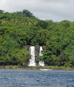 |
| Waterfall Bay |
Sept 28th - 30th, 2007
Waterfall Bay lies on the western coast of Vanua Lava in Vanuatu. The site studied for Vitareef conditions was the fringing reef on the southern side of the bay. The twin waterfalls lie just to shoreward of the study site. On the northern side of the bay, the reef takes the form of a narrow shelf composed mostly of large boulder corals. This area was consistently pounded by swells during our time here. In the centre of the bay, close to the beach, was a sandy bottom rising to form a reef shelf of 3-5m depth.
Vanua Lava is one of the chain of islands grouped together as the Banks Islands. This island group covers approximately 746 sq km of the northern portion of Vanuatu. Vanua Lava is centrally positioned in the chain. Waterfall Bay is home to one of the most dramatic sights in Vanuatu, Sara Falls. These twin waterfalls cascade directly into the ocean.
There are three very small villages in the vicinity of Waterfall Bay. In general, there is little tourism in Vanua Lava although the villages surrounding the bay make their livelihood from the waterfalls, the sacred red cliff caves and the coral reef in the region. Waterfall Bay is mostly visited by boat, but can also be reached by a two-day hike from Sola, the main administrative center of the Banks which lies close to the south east tip of Vanua Lava.
The total population of the Banks Islands is 7,700 with 2,000 living on Vanua Lava. Most of Vanua Lava's inhabitants reside on the south coast of the island.
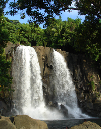 |
| Twin Sara Falls |
The Banks Islands were colonized around 1100 BC. Captain William Bligh of The Bounty officially mapped the positions of the islands in 1789.
No water temperatures were recorded during the course of this study.
No bleaching observed.
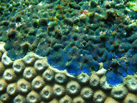
White band disease was observed on this study site. From Vitareef observations, 0.8% of colonies scored were suffering from this condition, all being table Acropora spp. colonies.
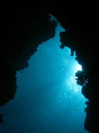 |
| Reef swim-through |
No visibility measurements were recorded during the course of this study.
The study site reef extends from the beach as a reef flat, rising to a depth of 5 metres at the reef crest. It extendes 400 metres off the west coast of the island. Living coral cover on the reef flat is low. There are swim throughs running beneath the reef flat, perpendicular to the beach, sometimes extending for 30m and re-emerging either back onto the reef flat or out onto the reef slope. The reef slope drops off steeply to a depth of about 20 metres to a sandy bottom with scattered coral bommies.
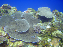 |
| Table Acropora spp. on reef top |
The reef top is dominated with table Acropora spp. colonies with some areas of dense coverage and most colonies being in a good state of health. There are also many massive Porites spp. and Diploastrea heliopora colonies throughout this site.
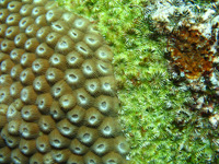
Many Diploastrea heliopora colonies were suffering from overgrowth by a very fine filamentous algae. Several colonies were being overgrown by a purple-blue macroalgae.
In one area of data collection the density of boulder Porites spp. was up to 60%. These colonies were often in good condition. The most frequently encountered Vitareef conditions on these Porites spp. colonies were edge damage or overgrowth by invertebrates.
|
|
No fish identification dives were conducted at this site, however general observations during the course of this study include two Manta rays at about 5 metres. The most common reef fish present were surgeon, wrasse and damsel fish. No pelagics were observed within the study area.
Several Acropora spp. colonies were prone to predation by a snail which we were unable to identify. In several cases, the tissue of the entire colony had been eaten away leaving behind freshly exposed skeleton.
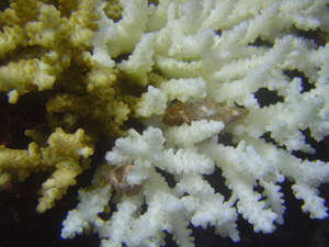 |
| Snail affecting Acropora spp. |
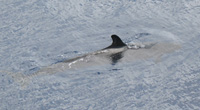 |
| Melon Whale Peponocephala electra |
While anchored in Waterfall Bay itself, we observed two pods of spinner dolphins jumping and feeding near the ship.
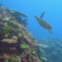 |
| Hawksbill turtle |
In general, Vitareef observations on 2,117 colonies revealed this reef to be in a state of excellent health with 63.7% of colonies scored as overall healthy compared to 24.9% of colonies under threat. Large areas of beautiful table Acropora spp. colonies dominate parts of the reef. It is clear that the remote location of this reef is a factor helping to maintain coral health.
Lying behind this reef and the Sara Falls are huge swathes of forest. The greatest potential threat to this reef would be deforestation of this area. The river and falls would carry great amounts of sediment directly on to this reef. Development on Vanua Lava has so far been contained to mostly the south and east coasts.